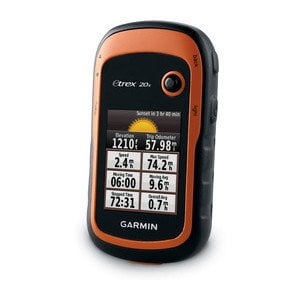
[vc_row][vc_column][vc_column_text]Garmin eTrex 20x is our upgraded version of the popular eTrex 20, with enhanced screen resolution for a more readable display and internal memory expanded to hold more maps. It retains the ease-of-use, durability and affordability that eTrex is legendary for and can also be used on ATVs, bicycles, boats, cars or hot air balloons.
See the Way
Garmin eTrex 20x has an enhanced 2.2-inch, 65K color, sunlight-readable display. Durable and waterproof, eTrex 20x is built to withstand the elements. It has an upgraded interface yet retains its legendary toughness to withstand dust, dirt, humidity or water.
Go Anywhere
With an array of compatible mounts,Garmin eTrex 20x is designed as a handheld or for use on ATVs, bicycles, in boats, cars even hot air balloons. Use the auto mount capability and
City Navigator NT® maps for turn-by-turn driving directions, or the rugged mount for your motorcycle or ATV. Wherever you think you might take eTrex, it has the mapping and mounts to get you there.
The eTrex series is the first-ever consumer-grade receivers that can track both GPS and GLONASS satellites simultaneously. When using GLONASS satellites, a system developed by the Russian Federation, the time it takes for the receiver to “lock on” to a position is (on average) approximately 20 percent faster than using GPS. And when using both GPS and GLONASS, the receiver has the ability to lock on to 24 more satellites than using GPS alone.
Add Maps
With its microSD™ card slot and expanded 3.7 GB of internal memory, eTrex 20x lets you load
TOPO 24K and
Garmin HuntView™ and hit the trail, plug in
BlueChart® g2 preloaded cards for a great day on the water or City Navigator NT map data for turn-by-turn routing on roads. eTrex 20x also supports
BirdsEye Satellite Imagery (subscription required), that lets you download satellite images to your device and integrate them with your maps.
Keep Your Fix
With its high-sensitivity, WAAS-enabled GPS receiver and HotFix satellite prediction, eTrex locates your position quickly and precisely and maintains its GPS location even in heavy cover and deep canyons.
Find Fun
Garmin eTrex 20x supports
geocaching GPX files for downloading geocaches and details straight to your unit. Visit
Geocaching.com to start your geocaching adventure. By going paperless, you’re not only helping the environment but also improving efficiency. eTrex 20x stores and displays key information, including location, terrain, difficulty, hints and descriptions, which means no more manually entering coordinates and paper printouts. Simply upload the GPX file to your unit and start hunting for caches.
Plan Your Next Trip
Take charge of your next adventure with
BaseCamp™, software that lets you view and organize maps, waypoints, routes, and tracks. This free trip-planning software even allows you to create
Garmin Adventuresthat you can share with friends, family or fellow explorers. BaseCamp
displays topographic map data in 2-D or 3-D on your computer screen, including contour lines and elevation profiles. It also can transfer an unlimited amount of satellite images to your device when paired with a BirdsEye Satellite Imagery subscription.[/vc_column_text][/vc_column][/vc_row]